Vltava Map
Complete overview of navigable sections of the Vltava from Vyšší Brod to Boršov nad Vltavou. Plan your perfect paddling trip with our detailed map and guide.
About the Vltava and paddling it
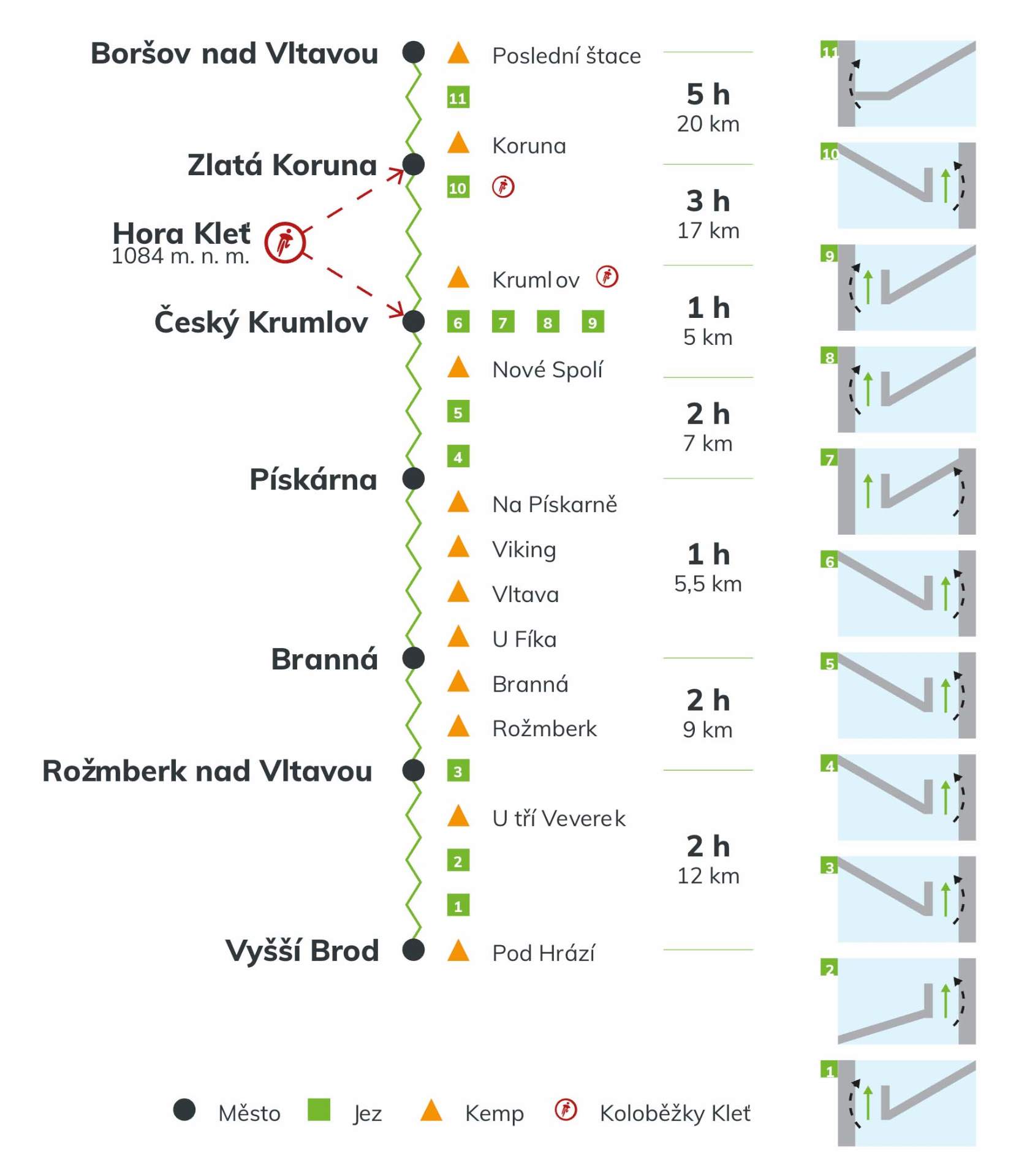
The Vltava is one of the most popular paddling rivers in the Czech Republic. The classic navigable stretch from Vyšší Brod through Rožmberk, Český Krumlov and Zlatá Koruna to Boršov nad Vltavou is about 68 km long and is manageable even for beginners and families with children.
Along the route you'll find dozens of campsites, many weirs of varying difficulty and historic landmarks – Krumlov Castle, Zlatá Koruna Monastery or the ruins of Dívčí Kámen castle.
Our boat rental in Český Krumlov will help you choose the right section, arrange boat, passenger and luggage transport and advise on current water levels.
- 25+
- let zkušeností
- 100%
- servis na míru
River Sections
Detailed overview of all 4 main sections of the Vltava with important points and recommendations for safe navigation
Vyšší Brod – Branná
1st part of the most popular middle section of the Vltava
About the section
The first section of the most popular part of the Vltava for canoeing or rafting. In Vyšší Brod, you can also start a 3-4 day paddling trip. Accommodation options include classic paddler camps and guesthouses. There are also plenty of restaurants and pubs in Vyšší Brod.
Paddling tips
The advantage of this section is good navigability, as it starts right below the Lipno II reservoir. The minimum water level required for navigation is 60 cm.
Waypoints
Jez u Bílého mlýna
Kemp Herbertov
Jez Herbertov
Tábořiště u Tří veverek
Rožmberk
Jez Rožmberk
Kemp Branná a Kemp u Fíka
Branná – Český Krumlov
2nd part of the most popular middle section of the Vltava
About the section
The second section of the most popular part of the Vltava for canoeing or rafting. In one day, you'll reach Český Krumlov, but if you want to paddle more, you can continue to Zlatá Koruna.
Paddling tips
The minimum water level required for navigation is 60 cm. You can check the current water level on the Povodí Vltavy website.
Waypoints
Kemp Branná a Kemp u Fíka
Kemp Vltava
Kemp Viking
Autokemp Na Pískárně
Jez Větřní - Pečkovský mlýn
Jez u Papouščí skály
Kemp Vltavan
Kemp Český Krumlov
Český Krumlov – Zlatá Koruna
3rd part of the most popular middle section of the Vltava
About the section
This relatively short section (17 km) can be enhanced with a longer stop in Český Krumlov, where we have other great experiences prepared for you: Kleť mountain scooter descent and night rafting through the historic center of Český Krumlov.
Paddling tips
The minimum water level required for navigation is 60 cm. In the center of Český Krumlov, you'll find many restaurants and refreshment spots.
Waypoints
Kemp Český Krumlov
Jez U Rechlí
Jez u Liry
Jez Mrázkův mlýn
Jez U Jelení lávky
Zámek Český Krumlov
Bývalý jez U Jatek
Kemp Krumlov
Jez Zlatá Koruna
Klášter Zlatá Koruna
Kemp Koruna
Zlatá Koruna – Boršov nad Vltavou
4th part of the most popular middle section of the Vltava
About the section
The fourth and last section of the most popular part of the Vltava for canoeing or rafting. You'll paddle mainly through natural scenery, winding through the Vltava meanders, and when you pass the ruins of Dívčí Kámen castle, we recommend stopping there.
Paddling tips
The minimum water level required for navigation is 60 cm. This section is calmer and more natural.
Waypoints
Kemp Koruna
Kemp Poslední štace
Zřícenina hradu Dívčí kámen
Boršov nad Vltavou